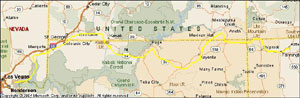
 This leg of the trip
takes us through the canyonlands... a four-state area of the US known for truly beautiful
canyons of sandstone and shale shaped by time into some of the most dramatic
forms on earth. This area has parks such as Grand Canyon, Monument Valley,
Bryce, Zion, Escalante and many others. We're hoping to make it to Zion, Monument
Valley and onto other parks in and around the four corners region. Here's the
map.
This leg of the trip
takes us through the canyonlands... a four-state area of the US known for truly beautiful
canyons of sandstone and shale shaped by time into some of the most dramatic
forms on earth. This area has parks such as Grand Canyon, Monument Valley,
Bryce, Zion, Escalante and many others. We're hoping to make it to Zion, Monument
Valley and onto other parks in and around the four corners region. Here's the
map.
The trip from lake Mead to Zion Canyon was very scenic. We took highways 167
- 169 along lake Mead to
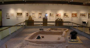
a place called Overton. In Overton, there is a great little museum on the
Anasazi Indians. They are ancient dwellers which all of a sudden disappeared in
the 1300's, and traces of which were found in settlements discovered and excavated
just in time before the flooding of lake Mead, due to Hoover dam. The many artefacts
extracted were brought to this and other ancestral museums on the first people of north
America.
169 along lake Mead to
a place called Overton. In Overton, there is a great little museum on the
Anasazi Indians. They are ancient dwellers which all of a sudden disappeared in
the 1300's, and traces of which were found in settlements discovered and excavated
just in time before the flooding of lake Mead, due to Hoover dam. The many artefacts
extracted were brought to this and other ancestral museums on the first people of north
America.
Movin'on we did an overnight at a casino in Mesquite off
Interstate 15. The trip basically followed a river called the mud river and this
river flows all the way from here into lake Mead. What's interesting is that we basically
followed a canyon gouged out by the flow of this river for a fifty miles or so,
and when we reached Mesquite, we ended up on the top of a plateau and you can
actually see some of the very beginning of the canyon where the mud river starts to gouge the sandstone plateau. What a Geographic lesson!
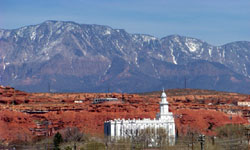
We spent the next morning in St George, a town started by the
Mormons when Brigham Young decided another agricultural area was required for the
needs of the inhabitants of Salt Lake City. Here you'll find St George Temple,
the end of the "Honeymoon Trail" I had mentioned in the Texas section of this
WEB. It is here Mormon's would go to get married and hence the ride back
home was called the "Honeymoon Trail"... :-) St George, by the way, is a large
agricultural area in the middle of a desert. We were told at the downtown Mormon
Tabernacle that even today, Mormon members still manage a peach farm having over 1,800 fruit
trees.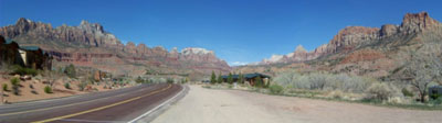
The road from St George to Zion goes through one of the most beautiful mountain passes we have seen; the grapevine pass. It's a new highway that was built through the range, and it's a spectacular stretch of road that's worth the side trip if you're in the neighbourhood. A few miles past the range and you start the drive down the valley of the Virgin river, the river that formed Zion National Park.
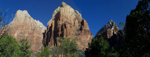
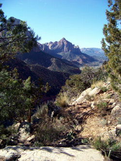
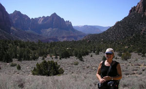
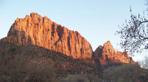
Zion National Park is like being at Grand Canyon, but at the bottom of it. It's a huge park but the main attraction is the drive along the seven mile long canyon at the south entrance, and it is chock full of grand mountain views, raised mesas and step valleys. Nothing says it better than pictures. This one on the left is of the three patriarchs, named so by Young. The one on the right is of a walk we did on Sand Ridge trail. A beautiful 4 hour walk through 3-1/2 miles of great real estate. If you ever take this trail, when you get to the start of the loop, go left. That way you'll get an easy one mile downhill walk on soft beach sand, instead of having to climb through it. By the way, this year marks Zion's 100th anniversary, the first park in Utah..
 If you visit Zion before
April 3rd, you get to drive up the valley in your vehicle. Much more convenient. After that date, you
must ride buses supplied, due to traffic congestion. Also, after April 3rd, you must make reservations
for the campgrounds, otherwise, it's on a first come basis and there's room
these days.
If you visit Zion before
April 3rd, you get to drive up the valley in your vehicle. Much more convenient. After that date, you
must ride buses supplied, due to traffic congestion. Also, after April 3rd, you must make reservations
for the campgrounds, otherwise, it's on a first come basis and there's room
these days.
This picture on the left, is also from the sand ridge trail and it shows Velma walking through a field of "Old Man's" sage grass. A great smelling herb used by cowboys to keep bed bugs out of the "sack". This part of the walk felt like a real desert walk as it got into the 80's, we were sweating and there was no cover.
Scenes like this one on the right can be had at almost every corner if you wait for the right light. As the sun moves across the skies, the scenery changes.
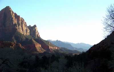
This one on the left is just off the campground and it's called the Watchman. Actually, both pictures are of the same mountain! We got tons of pictures, but you'll have to visit this place to see them as there are simply way too many to show.
If you plan on driving through the park, which mean you leave (or enter)
through the east entrance on Hwy 9, you should know that there is an additional
fee of $15.00 to use the one mile long tunnel if you have a trailer. The
tunnel was built in the early 30's and can only take one trailer at a time, so
you drive the centre line for a mile as they hold up traffic at the other end.
There is also one heck of a climb to
 that tunnel (or
drop) by way of a 6 corner switchback road that climbs about 750 feet. Add to
that another 300 foot climb while you're in the tunnel! Once you get on top
of this road, the scenery changes to something out of this world. You're at the
top of the mountains that make up the eastern range of Zion valley, and they are
made up of what is called "slickrock". It's sandstone, but it's a sandstone
that's so soft, you can break it off with your hands and some you can crumble
into sand with your fingers. There are miles and miles of this rock at the top
of these mountains and it's white due to the sun and leaching from
the rainfalls. The leaching also dissolves the "cement" that holds the sand
together. As you can see from this
picture, it makes for very different scenery from the one in the canyon.
that tunnel (or
drop) by way of a 6 corner switchback road that climbs about 750 feet. Add to
that another 300 foot climb while you're in the tunnel! Once you get on top
of this road, the scenery changes to something out of this world. You're at the
top of the mountains that make up the eastern range of Zion valley, and they are
made up of what is called "slickrock". It's sandstone, but it's a sandstone
that's so soft, you can break it off with your hands and some you can crumble
into sand with your fingers. There are miles and miles of this rock at the top
of these mountains and it's white due to the sun and leaching from
the rainfalls. The leaching also dissolves the "cement" that holds the sand
together. As you can see from this
picture, it makes for very different scenery from the one in the canyon.
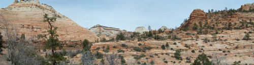
A quick geological prep: Zion is located in what's called the Colorado plateau. This is a huge chunk of land that was raised the height of mountains. It used to be under water and was desert at times. The thousands of feet of desert sands were over time turned into sandstone and the shale was created by the deposition of mud and sediment while undersea. When you look down the grand canyon walls, it's the same stuff you see layered along the walls. The nice wavy colors and layers of the upper rock formations were formed when gigantic, billion year old sand dunes, shaped by the wind, turned into rock. These are most prominent in the sand canyons we visit later on. The bottom of the Grand Canyon, the river bed, is on Precambrian rock, the oldest rock on earth... That's the stuff you find in Northern Ontario and Sudbury. So, you basically have, as thick as the Grand Canyon is deep, land a mile thick at places, created of sand and silt, being shaped by rivers, wind, rain and sun into valleys like Zion. When you get to the top of these mountains, you witness the weather turning rock back into sand, which over time will again be sand dunes. What's very amazing is this. About half way up the Grand Canyon walls, there is a layer where evidence of life is first recorded, 150 million years ago! That layer is now visible in many places in canyonland, and that's where they are finding T-Rex's bones. From the bottom to the top of Grand Canyon is the history of planet earth! Everything starts on the Precambrian shield rock, and that's why "Sudbury Rocks!" Interesting, eh!
Tomorrow, we break camp and move on towards the four-corners region. The only spot in the USA where four states meet at a corner.
March 23, 2009, Somewhere in Escalante - Grand Staircase Monument, UT 4,600 ft elev. - Temp 58
We left Zion going west so that we could do a "180" and travel the southern portion of UT
and northern AZ,
called the "Arizona Strip". It's a plateau of land stuck between one heck of
long 1,000 foot high cliff that borders the north side of the highway from Hurricane,
 UT to Kanab, with
canyons protruding to and making-up part of the Grand Canyon along the south. Windy and desolate country
imo.
UT to Kanab, with
canyons protruding to and making-up part of the Grand Canyon along the south. Windy and desolate country
imo. 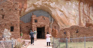 At Kanab, we wanted to see
a western movie set that is famous for over
100 movies, including TV series' like Gunsmoke, only to find it's farther down
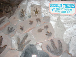
the highway. But we sure found an interesting spot near Kanab, called Moqui
Cave. This is one man's work, which at one time was a bar, and today, being
run by his son, it's a museum. It has a h-u-g-e selection of fluorescent rocks,
tons of authentic native artefacts, pots, arrowheads, etc, a large display of
prehistoric / Jurassic park animal tracks, fossilized in stone, and there is quite an
interesting family history to this museum. The Chamberlain family's ancestry dates back
to great-great grandpa Chamberlain with his six Mormon wives. Oh, and did I forget
to mention that this is all displayed in a cave! Yep, and there was a bar run
from it in the 60's... talk of a real "Hole in the Wall" that's
a must see if you're in the neighbourhood. Hey! I thought Mormons didn't drink!
At Kanab, we wanted to see
a western movie set that is famous for over
100 movies, including TV series' like Gunsmoke, only to find it's farther down
the highway. But we sure found an interesting spot near Kanab, called Moqui
Cave. This is one man's work, which at one time was a bar, and today, being
run by his son, it's a museum. It has a h-u-g-e selection of fluorescent rocks,
tons of authentic native artefacts, pots, arrowheads, etc, a large display of
prehistoric / Jurassic park animal tracks, fossilized in stone, and there is quite an
interesting family history to this museum. The Chamberlain family's ancestry dates back
to great-great grandpa Chamberlain with his six Mormon wives. Oh, and did I forget
to mention that this is all displayed in a cave! Yep, and there was a bar run
from it in the 60's... talk of a real "Hole in the Wall" that's
a must see if you're in the neighbourhood. Hey! I thought Mormons didn't drink!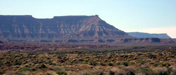
After Kanab, we headed into what's called "Escalante - Grand Staircase,
a
National Monument". This is a new park managed by
the BLM... first time BLM get to manage a park. It's only 13 years old and
encompasses over 2 million acres of some of the most beautiful canyonlands
ever. The name Grand Staircase derived from the fact that a cross section of
land from the north ridge of the Grand Canyon to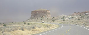 the top of the mountains 15t0 miles north, looks like a staircase. Picture on left
gives you an idea. On the way, we stopped at the
"Paria" movie set, THE old western movie set we were looking for, only to
find out it was vandalized and burned down a few years ago. Oh well, sometimes
better to have these things live on in memory. We then stopped at the
Escalante Monument visitor centre on few miles further on Hwy 89 at the Paria River for info on things to do
and see in the area. We arrived just in time for this sand storm you see to the
right. What an area to explore as there are many trails and things to see. We
found out that, in order to visit a very popular site called Cayote Buttes
nicknamed the "wave", we had to enter a draw in order to get a permit
for it. Only 10 permits per day are awarded at this
visitor centre for the following day. Now, as it happened, we boondocked close by the
visitor centre, and next to a couple from Quebec named Fernand and Rita.
the top of the mountains 15t0 miles north, looks like a staircase. Picture on left
gives you an idea. On the way, we stopped at the
"Paria" movie set, THE old western movie set we were looking for, only to
find out it was vandalized and burned down a few years ago. Oh well, sometimes
better to have these things live on in memory. We then stopped at the
Escalante Monument visitor centre on few miles further on Hwy 89 at the Paria River for info on things to do
and see in the area. We arrived just in time for this sand storm you see to the
right. What an area to explore as there are many trails and things to see. We
found out that, in order to visit a very popular site called Cayote Buttes
nicknamed the "wave", we had to enter a draw in order to get a permit
for it. Only 10 permits per day are awarded at this
visitor centre for the following day. Now, as it happened, we boondocked close by the
visitor centre, and next to a couple from Quebec named Fernand and Rita.
The next morning, if it wasn't for Fernand giving me a ride up to the visitor centre, we would have missed the draw by the 9:00 am deadline We made the application at "ten to nine" AND, we were drawn on the first number! What luck! We were told folks wait days to get a pass, and Rita knows of a couple who waited three days and finally left.
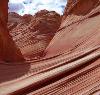
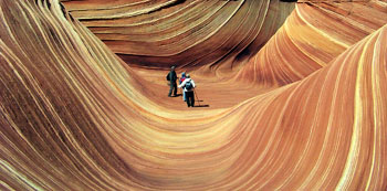
The next day, we all went for a grand, six mile walk-a-bout to the Wave. It was not disappointing. As you can see from these pictures, it is one of the many spectacular sites in Canyonlands. Amazing what winds can do to sandstones in the windy canyons of the upper mountains. And the walk there was also just as spectacular over mountain passes and mountain top "buttes" and mountain sides, all shaped by the wind in similar fashion to the waves.
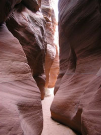
In addition to the waves, we
took a walk down Wire Pass trail which leads to a "slot canyon" that goes to the
confluence of Buckskin gulch. This was a nice canyon with some spots being only 18 inches
wide.
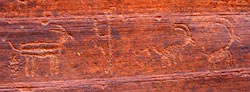
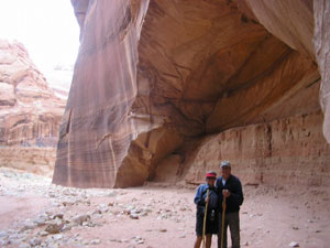
At the confluence, it had dug out a huge gothic hole out of the rock (right). We
also found un-tampered petroglyphs along the wall past the hole behind
Velma. You can tell real 'glyphs by the fact they have a coating of "laquer"
(patina)
and are almost the same color as the rock they were chiselled out of. Laquering
takes hundreds of years. Recent counterfeits would show a color of
that of the stone it was made in. These 'glyphs depict longhorn sheep.
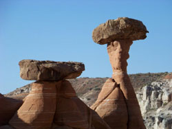
The morning we left, we did one more walk to what's called the
"Toadstools".
Toadstools, also known as hoodoos, are columnar rock formations having a stool over the top. A quirk of
mother nature for sure, and a wonder they are still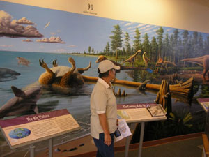 standing and have not all
been toppled over. They look like something right out of a Disney movie. It's
quite a lot to see and from a trail map we got from the visitor centre, there
are at least another five trails in the area. Looking at the overall Monument
map, the northern part of Escalante appears to offer even more and we'll have to
pincushion Utah 12 for the next trip.
standing and have not all
been toppled over. They look like something right out of a Disney movie. It's
quite a lot to see and from a trail map we got from the visitor centre, there
are at least another five trails in the area. Looking at the overall Monument
map, the northern part of Escalante appears to offer even more and we'll have to
pincushion Utah 12 for the next trip.
Between Page and the Paria river is a town called Big Water, with a newer Escalante
visitor centre that is a must see. They have the
low-down on the local dinosaurs and let me tell you they are finding a ton of
them around these parts. The displays are great and the attendants at this
office are sometimes Geologists, Anthropologists, Palaeontologists, when they
are not out scouting the park. The mural above depicts scientific representations
and qualified assumptions of
what the scene would have looked like 75-150 million years ago. That mural you see took the
commissioned artist
one year to paint, and it's all on one sheet of canvas, glued to the wall. What an
visitor centre.
We did the late morning
in Page, AZ... I believe. It's really complicated 'round these parts. As you
drive east or west, the highway meanders in and out of Utah and Arizona. On top
of that, you have to adjust the time because AZ does not Spring forward and
other states do.
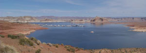
Page is also famous for the super scenic lake Powell...another man made wonder
created by the Glen Canyon dam, set against a beautiful and stark desert landscape. But it's Winter and
no-one's around to use the thousands of houseboats we see.
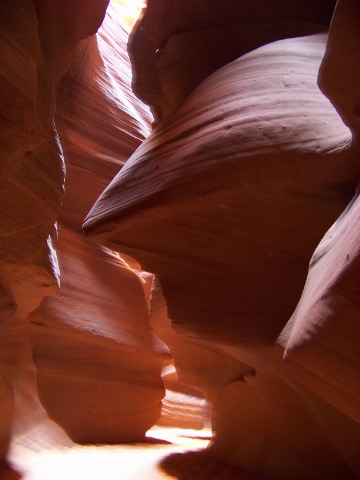
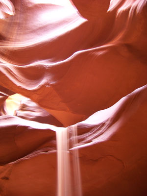
This morning we also did Antelope Canyon while in Page... a
famous, and the most photographed of all slot canyons around, I believe. I'm guessing
this by the number of tourists
in Page at this time of year and Antelope canyon being the only thing to see.
The picture on the right is a sand waterfall, created by the tour guide. What a spectacular canyon.
A suggestion if you go... You can drive up to Antelope Canyon and pay the $26 per head fee, but after a half hour getting in and out of the canyon, it leaves you a half hour "in" the canyon... OR... you take a tour in town and for $32 you get a free ride... no stairs... and a full hour "in" the canyon.
Late this afternoon, we should make it to my favourite of all Canyonland places... Monument Valley.
March 26, 2009, Monument Valley, UT and AZ - 5,500 ft elev. Diesel $2.29 and it's cold!
Monument Valley is always a treat, whether it's warm, cold, raining or
snowing. The views of the buttes are ever changing with the light and weather.
The scenery of the valley is rustic as many Navajos live in the valley among the
buttes and some live in the traditional "Hogan". As a matter of fact, travelling
the Navajo Nation is a treat. It reminds me of what the "West" might have looked
like years ago, because development is restricted. You can travel for hours and
never see modern development.
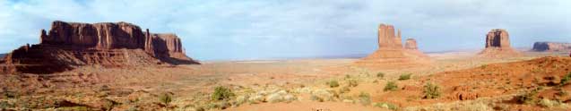
This is our second visit here, since we were driving by. Plus, we wanted that
famous view we last had from our "up front" campground. Unfortunately, the
Navajo Tribal Park has decided to build a brand new hotel and they placed it
right on top of our campground! But they have seen fit to accommodate us with
another "up-front" view by letting us boondock in the viewers parking lot, on
the edge of the escarpment, with unobstructed views no less. And what views!
While there though, we never had a chance to visit the valley floor since we
got in late on the first day. The next day we got snow, rain, wind, sun and sand
storms, all in one day! Hello... snow!
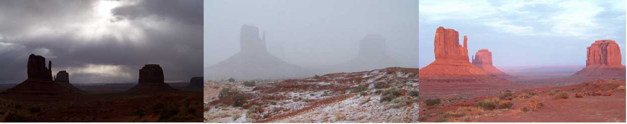
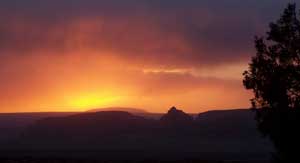
By weathering out these various weather conditions, and just lazing around the
"house" all day, it offered us the opportunity to photograph the scenery under
all sorts of weather and light conditions. The three sequence of
photographs above are just to show you what you can get of the same scene on the
same day! 1) Early morning storm clouds 2) Late morning snow storm 3) Evening
sunset with dust storms on valley floor.
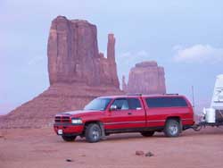
Just to give you an idea of the size of these buttes, take a look at the truck parked about a mile away from the first butte on the right side of the above pictures.
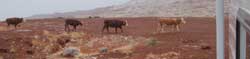
You know what else is neat about being on Navajo lands, you never know what to
expect for supper...
But, I'm sure you'll agree, the views around here
are great even if you just stay put in the viewing lot.
I love this place!
Tomorrow, we break camp for Mesa Verde and the 4-corners region.