|
The Klondike(by Denis)
|
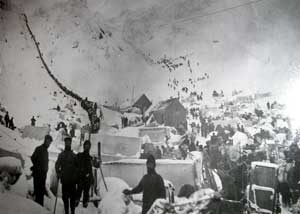
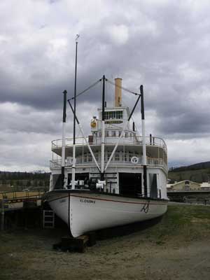
From Whitehorse, the Klondikers had to navigate the waterways of the Yukon
river. Near Whitehorse was the mile canyon, a fast water / rapid channel and
further on the fingers rapids.. see picture in Yukon web page. Many lost their lives and many more lost their
outfits ( the one ton of food and gear was called an outfit) especially when loaded
onto a crude boat or raft built over the Winter of 1896-97 at lake Labarge.
 This was the first hurdle... Mile canyon. Today it's calmer as the City of Whitehorse has dammed up the river just east of Town for a hydro electric power generating station.
|
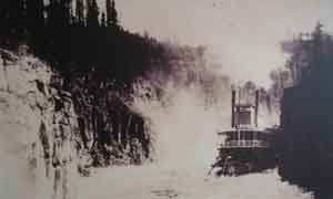 This is a picture of one of the fingers rapids. Here you see a stern paddle wheeler navigating upstream one of the rapids. What they did was tie a steel cable at both extremes of the rapids and winched the boat through the rapids slowly with a steam deck winch.
|
|
|
The discovery of gold by Carmacks et.al. was found on gravel bars and gravel shoals in the Bonanza creek, Gold Bottom Creek and the Eldorado Creek. This gold was panned and it was so rich that by the Winter of 1896 quite a few miners were rich beyond their dreams. They sailed the Spring of 1897 out to Seattle and San Francisco with their "tons" of gold and this is what started the gold rush. Gold
Placer mining started with panning
gold from the creeks of the Forty Mile region, near Eagle, AK (see Alaska web page)
and the town of Circle downstream from Dawson. Dawson only started as a town early in 1896.
The
local miners soon had all the good ground "claimed" and by Winter of 1896
most miners panned and depleted the gold from the easily accessible creeks. By the time the Klondikers arrived, all the good claims were gone and all that was left was
working for the claim owners. Gold being depleted from the easily accessible sand bars, forced the miners to go underground where they found the ancient riverbeds of the Bonanza, Eldorado, Gold Bottom and Hunker creeks as well as the bottom of the Klondike river itself. Here, through millions of years of erosion, the gold was settled on the creek/river bed rock, but, it was locked in the permafrost and that's where the work started. Through innovative methods of building small fires, these miners melted the permafrost to the old creek beds and bedrock, inches at a time. They then followed the incline of the ancient streambed and headed towards the deepest part to extract the alluvial gold which had concentrated there... and all done by back breaking hand. They would haul to surface this muck and pile it for Spring, when they would sluice the muck to separate it from the gold. This method of mining lasted for a few years and after depleting the "concentrated" gold from the ancient river/creek beds, it was no longer economical nor feasible to continue extraction of the less concentrated areas. But, many times, it was reported that the gold was so concentrated when mining the bottom of the creek beds, that a pan of gold would fill a bag! Depletion, necessitated a new mining method called "dredging". Individual mining claims were consolidated into huge tracks of land. A few large well funded companies were created and dredges were built to mine the remaining gold. It was mass production at its best. Dredges would extract all the soil from one side of the river bank to the other, all the way down and include a foot or two of bedrock (which is fragmented and soft around here), then sluice the whole works on board, so as to separate the gold from the ore, and leave behind a legacy of miles and miles of these telltale tailings... piles of gravel which look like bulbous worms all over the landscape. This method of mining lasted well into the 1950's. Today, mining is done by mostly
family and one-two man operations called Placer miners. Placer word derived from
"placed gold from somewhere else". There are between 90 and 110 placer
operations at any one time along the same rivers as was being mined 100
years ago. There's the Bonanza creek (our trailer park is located at the
mouth of the Bonanza creek and the Klondike rivers, 1 mile east of the Yukon river
at Dawson), the Hunker, the Eldorado and the dozens of tributaries (called
pups) to these rivers/creeks
plus a few more
in the area. But most of the gold from the Klondike is in the Gold belt
surrounded by the Bonanza and Hunker creek regions... all about 15 kms
apart. |
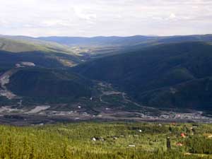 View of Bonanza creek and the mining operations from the "dome" above Dawson City. At bottom of the page is the Klondike river and our campground right at the confluence of Klondike and Bonanza. You can literally see for miles up this creek at the mine tailings. |
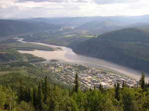 View of Dawson City and the Yukon river looking south - upstream. The Klondike river is just past the city in the bend going left and the picture to the left is very close to being a match.
|
 Ah... The joys of panning. Here I am panning the Bonanza creek at claim 6, just 3,000 ft above Carmacks discovery claim. Claims were 500 feet long along the stream, went bank to bank, and were then numbered from the discovery claim as claim #2 below or above (meaning below or above stream). This is a back-braking job and there is no gold left here! |
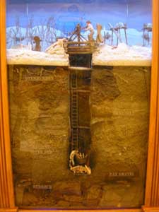 Mining soon moved to shaft and tunnel. This is a diorama of what shaft mining was like as they built small fires to melt a half foot of permafrost at a time, so they could reach pay dirt and bedrock. The gold was found concentrated along the bottom of ancient river beds, of which the Bonanza was one. More fires were built to melt off more permafrost horizontally, so as to move along the creek bed to your claim boundary line. |
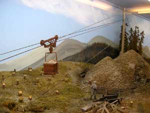 As the muck was being removed from the shaft and the drifts, it was piled up above so that in the Spring, it would thaw and could be sluiced so as to separate gold from muck. This operation was called the "cleanup". This diorama displays an example of such an operation. The self unloading bucket shown above was a later invention which greatly eased this operation. By the way, these great dioramas were taken at the Fairbanks Heritage Village museum and were done there by an artist whose name was not credited... but they were the best I had ever seen. |
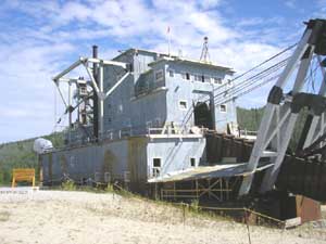 The next evolutionary step in mining the Klondike was by the use of dredges. This is dredge #4 of the Canadian Klondike Mining Co. Ltd. A corporation started by a man named Joe Boyle of Toronto. This 200 ton behemoth, has of wooden hull type and operated till the mid 1950's. It paid itself off in the first few months of operation! Basically, these machine had a bucket chain at the front which scooped all the gravel including 2 feet of bedrock and passed the whole works through screens. Anything 1.5 inches or less was sluiced to separate the gold. |
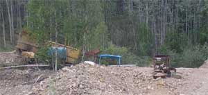 Today's Placer miners' operations range from small operations like the one above which uses a small shaker / sluice combination to huge shaker/drum screen sluicing machines like the one to the right, which require huge equipment to move the thousands of yards of gravel needed to keep such machines operating at capacity. Fact is, all of today's
operations still basically run on the same principle of that old
prospector's gold pan.... they move gravel with the use of water, and
because gold weighs 19 times more than water and 4 times that of gravel, it
will remain behind when agitated over such things as riffles, bedrock, angle
iron, or just the circular swishing of water in a gold pan... |
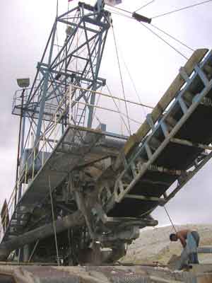 Modern machines such as this use shaker screens or screen drums to separate the gravel from the rocks. Water usage is in the thousands of gallons per minute! The thought here is... the more gravel you process, the more money you make and we hope these fine folks do good. |
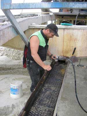 The bottom line is... GOLD!... This is what it's all about. And this fine young man, as you see, is smiling, right! As a matter of fact, he's always smiling and I think it's because he's got the greatest job in the world! See why? |
Enough of Gold! Now we move on down the Casiar highway of BC.
|
Home l The Beginning l Next
|